
Day 1: Monday Aug. 5th

We arrived at the Chepeta Lake Trailhead (elevation: 10,500 feet) about 10:15 am and started hiking just after 10:30 am. Dreampacker and Trailblazer (my wonderful parents) were kind enough to shuttle drive us, hike with us for a few minutes and then turn around and meet us at the other end in about 6 days.


 North Pole Pass (elevation: 11,800).
There was thunder and rainy wind and lightening in the distance while we were up there, so I tried to hurry down the other side. Not smart. With the wind blowing my poncho around I mistepped and fell twice! I was immediately grateful for my trekking poles which saved me from a much harsher landing:)
As the afternoon drew to a close we started looking for camping spots near a lake with possible fishing available. The Bishop was not feeling well with a really bad headache, abdominal pain and back pain. We didn't go as far as we had planned that night so he could rest a little bit and try to feel better. With evening sprinkles of rain, we set up camp at Dime Lake. No one fished, we just took care of basic camp needs of food, water and shelter. Rob and Dan gave the Bishop a blessing and we called it a night.
Day 2 ~ Tuesday August 6th...My Birthday!!
What a difference a day and a priesthood blessing make! Bishop was a new man ready to bounce down the trail, Dan was recounting to us his "bear scare" in the middle of the night and I was taking pictures of the beautiful morning on the lake:) Dan had heard an animal in camp for about 30 minutes during the night so he lay awake in his tent with his knife clutched in his hand. In the morning, he discovered tracks of a deer all over the place. It had helped itself to the Bishop's dinner that he left in a plastic bag because he was too sick to eat it.
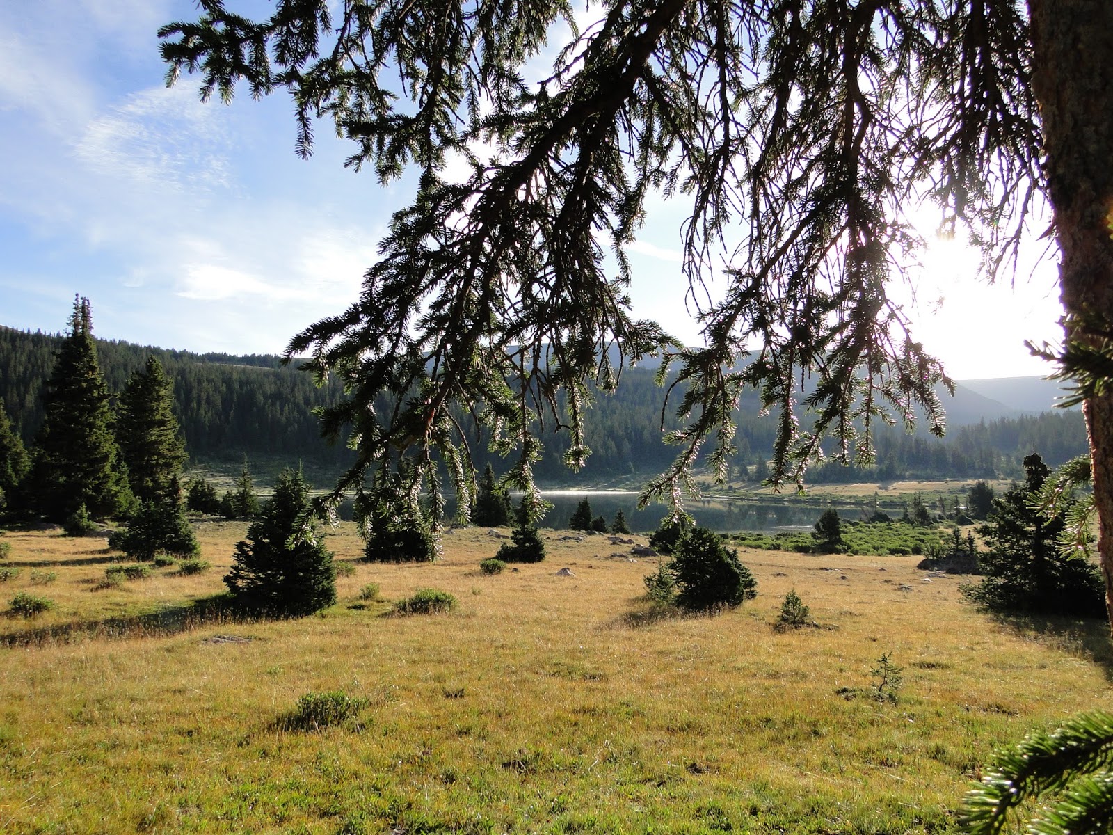
Dime Lake, from our camp.


Camped at a pond just below Milk Lake (elevation: 11,000).

Day 3 ~ Aug. 7th
We were able to get things aired out, packed and hit the trail close to 9:00 am. We hiked across Painter Basin and reached the trail junction of Anderson Pass and Gunsight Pass around 11:15 am. Dan and the Bishop took a side route at about 10:30 am to go check out another lake that a "trip report" said had some big fish in it. Rob and I knew they were faster hikers than we were so we were not worried about their side excursions. They knew we were headed over Anderson Pass, down and across the Yellowstone Creek Basin and over Tungsten Pass and would try to be camping @ North Star Lake that night. They could meet us there that night or catch us there the next morning. It took Rob and I three hours to hike up Anderson Pass! 3 hours of the Stair-master @ 12,000 feet with a 30 lb. pack on! Then it took another hour to carefully hike down the other side! An hour of lunges!


I've learned from running relays, that the trick to doing it successfully is a little bit of rest, refueling, and rehydrating can go a long way:) Unfortunately I was refueling with simple carbs and protein rather than complex carbs and protein. In other words, I was eating the wrong trail mix for most of the day. I was eating my dried fruit and nut mix rather than my crackers and granola bars. It wasn't until I downed a granola bar at the bottom of Tungsten Pass and I felt so much better, that I realized my mistake. I need a "re-do".
Mistake #2 ( THE BIG ONE) - I took the wrong sleeping bag. In trying to save weight, I packed a lighter sleeping bag and threw in extra socks and fleece tights instead. I was pretty cold the first night, really cold the second night and dreading this third windy night. I finally confessed to Rob my mistake and he offered to trade me sleeping bags:) Much to his demise, I slept comfortably the rest of the trip and he was quite miserable. He must love me!! I need another "re-do".
The weather was rainy and windy on and off throughout the day. We needed a wind break for cooking and hopefully for our tent, so we started looking for a suitable shelter for camp long before we reached North Star Lake. Crossing Yellowstone Creek Basin was mesmerizing, however. It is one of the most beautiful places in the Uintahs. We came upon a scout troop camped there. We guessed they were probably aiming for King's Peak or had just done it.
We were unable to find any trees of any kind to provide a good windbreak as we made our way up and over Tungsten Pass ( just a speed bump really - elevation: 11,500), and ended up near North Star Lake (I call it the Arctic Tundra Camp- elevation: 11,350) in a clump of scrubby bushes at about 6:30 pm. By the time we pitched our tent, cooked our dinner, ate and sat and watched the trail for a few minutes, it was almost 8:30 and Rob was done. He crawled in the tent and commenced trying to warm up "the sleeping bag from Hell". I stayed out sitting in my camp chair (luxury item that I highly recommend), reading my book and watching the trail through the valley for any signs of "the boys". When it got too dusky to read, I brushed my teeth, took one last glance across the valley hoping to see the Bishop and Dan and then crawled in the tent and tried to snuggle with Rob to keep him warm:) After about 10 minutes, we heard, "Hello in camp!" Rob whistled, and we turned on a headlamp. The Boys were back! It was just after 9:00 pm. They hurried and pitched their tents in what little shelter from the wind we had behind the bushes and then we called it a night:)

Day #4 Aug. 8th
I woke on and off through the night to the sound of the wind blowing and flapping the tent fabric, but I was so nice and warm in the sleeping bag that I went right back to sleep until about 6:00 am. I noticed the sky starting to lighten but waited until after 7:00 to peek outside the tent. Dan and the Bishop were a few yards away looking down into the valley.
Dan said, "Heather! There's a herd of Elk down there if you want to get your camera!"
Without getting out of my warm sleeping bag or the tent, I handed my camera to Dan and told him to go shoot some Elk:) He was very happy to oblige...

While The Boys were off "shooting", Rob and I got up and started breakfast and broke camp. We had 2 stoves that we were sharing between the 4 of us. The Bishop had one and we had one. I learned on the previous mornings how to avoid eating cold oatmeal. Even though I poured boiling water into my cup and mixed it with my oatmeal, the metal cup was so cold and the wind was so chill that by the time I was only halfway through, it was quite cold again. So now I keep the stove next to my camp chair and quickly light it again, set my cup of breakfast on the flame for a few seconds, and ta-da! Hot Cereal. For about 3 minutes. I need to learn to eat faster:)
Dan and the Bishop didn't eat dinner the night before so they were quick to use their "extra" meal they brought for such an occasion.
After breakfast we filtered water from Garfield Creek that runs into North Star and headed up to the top of Porcupine Pass (12,236). What a view!


Dan tried to tempt us with a side excursion by mentioning that Red Castle was "just over the red ridge" that is on the right side of the above photo. By looking at the grin on his face, I hoped he was only half serious...with the excursion, not the location:)
As we looked at the valley below us and the guys studied the maps, they pointed out the landmarks where our camp for that night would be. It was decided that we had about 13 kilometers to go, or about 8 miles. I looked down the pass and across the valley and said,
"It looks like 30 miles to me! Let's get going!"
So we did:)
As we got close to the bottom of Porcupine Pass, a solo trail runner came flying down behind us. As we moved aside to let him pass by, he slowed down enough for us to ask him where he started, what time, where he was heading and when he would be out. Henry's Fork, this morning - Mirror Lake tonight. As we sat at the bottom of the pass having a snack/refuel break, we could still see him running down through the valley. I often thought of him over the next 3 1/2 days as I hiked the same trail that he was running.
As we made our way through the valley and over to Lambert Lake I continued to marvel at the vast, beautiful scenery, the meadows and mountains and really enjoyed being with my honey in such an awesome place.


Rob and I dropped our packs under the shelter of the trees and we were debating on setting up our tent right then or waiting until the rain stopped. We turned around and saw Dan whipping out his tent and asked his opinion. He said in a very dry voice and with his customary smile,
"You never know. The rain could go all night."
And then he grabbed his poncho and his fishing pole, and started to walk around the lake to see if there were any fish to catch.
Well, on that note...we set up our tent and threw our sleeping bags inside.
And then guess what happened...


It turned out that the 2 fish in Lambert Lake were not as hungry as we were, so we commenced doing laundry and the other simple camp chores that I have found to be very meditative, humbling and enjoyable:)

Dan built a nice fire and as we dried our clothes, the Bishop mixed up a wonderful patch of brownie batter with chocolate chips in it. He "cooked" it in his pie tin over the fire, which actually means it got nice and warm and gooey. We took turns eating it with a spoon:) Good stuff. Good times.
As we were enjoying the campfire, Dan suddenly said,
"Heather! Do you have your camera? Look at the sunset!"
And this is what we saw...


BEST. DAY. EVER.
Day #5 - Friday Aug. 9th
We hit the trail and started making our way over to the Lake Fork River drainage. This drainage flows south into Moon Lake. At the trail junction we turned right and headed up the sheep-filled valley towards Red Knob - our pass for the day.

We were rewarded with the most incredible view of both the south slopes and the north slopes of the Uintah Mountains. It was my favorite view of the whole trip:) The photos just don't do it justice. My jaw literally dropped as I reached the top of this pass and looked at all the grandeur around me (Red Knob Pass elevation: about 11,800 feet).


"It looks like about 30 miles to me," I said :)
So, Rob and I started heading down Red Knob Pass into the West Fork of Black's Fork. Dan and the Bishop spent a few more minutes enjoying the view and checking out an old horse grave they found and then they followed us down.
We were once again getting close to camp at Dead Horse Lake (elevation: 10,878) when it started to rain and I started to pray. Gratefully we were close enough to the lake that Dan and the Bishop scouted out a great campsite for us. The Boys generously offered us the "honeymoon suite" for our tent. It was the most sheltered spot under the trees with a nice place to set up a "kitchen" and keep our packs dry.
Our kitchen...

Once the tents came out, the rain slowed down and soon stopped. Thank YOU! The guys grabbed their fishing poles and headed for the lake.

I started gathering firewood and heating water for dinner.
Once, as I came back and forth from camp with wood in my arms, I came up the hill and startled another hiker in our camp. He immediately introduced himself as "Dave" and said we had a great camping spot. He was looking for some live trees that were close enough together to hang his hammock up in. He also commented on our lightweight tents that were pretty cool and the fact that if we needed anything, he had bear spray and a side arm... That was when I informed him that my husband and friends were down fishing at the lake, and if we did need anything, we would let him know:) Rob got quite a kick out of that guy when I told him about him.
Apparently in order for that storm to be "blown away" the wind had to pick up a bit. I decided that the more firewood we had, the better. It was a good thing. The guys came back from the lake very damp, cold and shivering. But with some tiger trout! The words "Oh, bless you Heather!" came out of the Bishop's mouth as he came into camp shivering and all the wood was already gathered and Dan had a big fire going. We not only enjoyed another night by the fireside, although a little bit breezy, but we finally got to enjoy some fish filleted up and cooked by Dan:)
It also looked like I had only one more night before I tackled the dreaded...Dead Horse Pass. It was the source of most of my anxiety the past 5 days and the view I stared at all evening trying to see a path somewhere going up that ridge...*sigh* I couldn't really see one, but I knew there had to be one there.

So, the next morning we headed up...
Day #6- Saturday Aug. 10th


When I told Dan to pose somewhere for a photo, this is where he ended up:)


After awhile the Bishop had some luck and caught a fish, and nearly a boulder in his lap as well ( just a little rockfall - geological time includes now), but by that time Rob and I had decided to make our way to Jack and Jill lakes and try our luck there. We bid the Boys adieu and let them split the fish between them and we headed along the trail. We told them we would be waiting for them at Jack and Jill. Little did we know, they would be supplementing their fish lunch with ramen noodles that they found along with a left-behind boy scout camelbak:) Luckily it had the scout's contact information on it and his long-lost missing pack (minus the ramen) will be making it's way back to him courtesy of Dan.


As we came upon Jack & Jill, the thunder started rolling and bouncing off the cliffs around us and it started to sprinkle a little bit. We took off our packs and found a dry spot under some trees near the lake shore and Rob threw a line in the water. I relaxed with my camera and a snack under a tree.
After only about 15 minutes of Rob fishing, Dan and the Bishop caught up to us. Seeing that Rob was having no luck, we decided to pack up and get going to Brinkley Lake, our goal for the night. As we got closer to camp, the clouds parted and the sun started shining!


I was really hoping for a clear night so I could see some shooting stars. So I started praying for one:)


We reached Brinkley Lake, set up our tents and got out our fishing poles. I fished for a few minutes and then gathered firewood. Dan was the only one to bring in a fish that night and boy was it ever yummy! We also had several curious visitors in camp during the evening...

...and the skies stayed nice and clear...

Day#7- Sunday Aug. 11th - our last day.
Sunrise on Brinkley Lake.

Due to the beautiful clear skies during the night, it was a rather cold one, and a cold morning. We cooked and ate as much of our food as we could the night before and that morning as well. We had about 12 kilometers (around 8 miles) to go that day, including up and over Rocky Sea Pass, to make it out to the Hayden Pass trailhead near Butterfly campground where my parents were expecting to pick us up. So we headed out!
I love tackling a pass first thing in the morning!

...and we're at the top! From the looks of the landmarks, it seems to me like there are about....

30 MILES TO GO! We better get going!
The view from the top of Rocky Sea Pass looking east, back the way we came (elevation: 11,500). I had the sudden urge to actually turn around and go back! I didn't want it to be over quite yet:)

After putting my shoes back on and having a snack, Rob suggested that we take off and try catching an arctic greyling fish at Carolyn Lake on our way out. I was up for it, so we took a little side trail for a couple hundred yards and I was able to catch a small one in a fairly short amount of time. We released it so it could get bigger and we could continue on our way down the trail and back home. The Boys were waiting for us at the trail junction.
We still had about 4 hours of hiking to go so I put the camera away and we made some fast tracks.
Rob and I kept up with Dan and the Bishop for about 1 hour but it was tough. I was reminded once again what strong hikers they are and how much they actually stopped and waited for us throughout the trip. From that point on they just stayed at their own pace and we stayed at ours. They made it back to the trailhead about an hour ahead of us.
With about an hour or so still to go, it started raining. Rob and I stopped and got out our ponchos one last time. We didn't have them on for very long. It was too warm as we hiked and the sprinkling stopped for awhile. But as we got closer and closer to the trailhead, the skies opened up again. I kept thinking that we must be close, and I didn't want to stop and get out my poncho again. So, to keep my camera as dry as possible and to get to the car before a real downpour happened, I kicked it into high gear and flew up the last hill as fast as I could. Just as I started to hear cars on the highway, I looked up and saw my Dad on top of the last ridge standing in the rain, keeping watch on the trail, and waiting for his daughter to finish the Highline!

AND WE DID!!! The yellow trail marked on the map below is the Highline Trail that we followed across the Uintah Mountain Range.

So...would I do it again? In a heartbeat. And I hope I would do it better. Simply because I learned so much.
Here is the short list.
1. Don't count on catching fish to supplement your meals. Take enough food to refuel and stay warm.
2. Take the good sleeping bag. It's totally worth the weight.
3. The camp chair luxury item was totally worth the extra 2 lbs as well.
4. Take a decent poncho/rain gear.
5. Sleep with your camera batteries. I started doing this by the 4th night and it saved a lot of "juice" and even seemed to recharge them a little bit.
6. I wore the correct socks and shoes for me. No blisters and only slight foot soreness on the last day.
7. Take a pair of gloves and good friends with GPS's and brownie mix!
8. I loved my trekking poles, the Buff my daughter gave me for my birthday, my Columbia jacket and knee pants and my cute hat:)
9. I also loved my water bottle holder, my camera case and my sleeping pad...and the flaxseed corn chips that I got from Winco but didn't take enough of with me!
10. But the most important thing I took with me was my husband. He makes me a better me and is willing to take me anywhere I want to go. No trail is the same without him. I'm happy to have shared so many with him. Especially this one!
And by the way, I get it now :)
Get what?
Why people go there and go back again and again.
I get it :)
3 comments:
Aaah..... *big sigh* So awesome. Amazing journey...and people! way to go! Love it!
Wonderful narrative and photos!
One of the best Highline trip reports yet! Thank you for posting.
Post a Comment